Home > Weather FAQ > What do the Colors On the Weather map Mean?
|
|||||
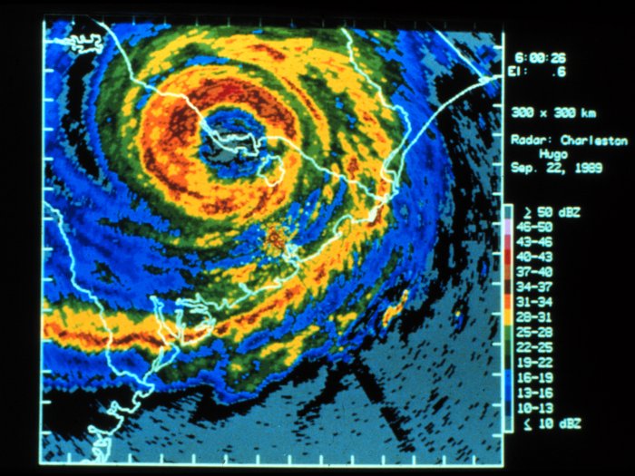
This is one of the most commonly asked questions. The answer depends on which maps you are looking at. Most often this question refers to the radar maps commonly seen in television broadcasts, which tell about weather moving through your area. There are different types of weather maps. What you are most likely talking about is the color radar maps seen on TV. The different colors represent the intensity and precipitation. The colors represent decibels of Reflectivity (Dbz), which is the amount of power reflected back to the radar receiver. if you look at the maps, you will see a Dbz scale right next to the color scale. The two are related. As the strength of the signal reflected back to the receiver increases, the Dbz number increases. The scale relates to the intensity of rainfall as well. The higher the Dbz, the stronger the rainfall. Hail, for example is a good reflector of energy and will return very high Dbz values. In addition, these maps show movement and locations of weather phenomena. These radars can show us many things, like the hook echoes which are indicative of a tornadic thunderstorm. Also, it is not well known that radars have two modes. One is the precise clear air mode and the other is a precipitation mode. GENERALLY SPEAKING HERE ARE THE MEANINGS OF COLORS:
Our website is dedicated to promoting interest in and better understanding of weather. WeatherWing has been the #1 Weather Observer Certification Training source for Oil and Aviation Interests in the Gulf of Mexico since 1998.
Source: http://WeatherWing.com Copyright 2007 all rights reserved
| |||||
Home > Weather FAQ > What do the Colors On the Weather map Mean?
|

"I'd worked as an observer for years, but needed to re-certify. I learned more in this course than I ever imagined I could and I passed the exam with flying colors. I am also definately a better observer" TS, Louisiana
I knew nothing about weather at all. My new job depended on passing the weather observer certification test. Thanks to the patience and personal attention you gave us all, the entire class passed. JB, Texas
"When my company sent me to this class I thought I didn't need the training. I was wrong. Thanks" RB, Texas
You are the "Gold Standard" of teaching. Absolutely the best teacher I have ever had. DG, Louisiana

Copyright 2007 -2010 all rights reserved
 Twitter
 Technorati
 Stumbleupon
 Google Bookmarks
 Facebook
 Digg
Digg Blogmarks
 Delicious
 BlinkList
 Yahoo My Web