| How Hurricanes are Rated |
| Back | Print
|
Bookmark |
|
| The Saffir-Simpson Hurricane Wind Scale |
|
The Saffir-Simpson Hurricane Wind Scale is a newer 1 to 5 categorization based on a hurricane's
intensity at landfall. Historically, the scale (then known as the Saffir-Simpson Hurricane Scale) used central
pressure and storm surge as components of the categories. The problem with this method was that there are too many
variables that influence storm surge.
Since accurate wind speed intensity measurements from aircraft reconnaissance have become more
available and to reduce public confusion about the scale, the storm surge ranges, flooding impact and central
pressure statements are being removed from the scale and only peak winds are employed in the revised version -
the Saffir-Simpson Hurricane Wind Scale.
The scale is based on wind speed and corresponding incurred damages. Generally speaking, damages
caused by a hurricane will increase times four with every category increase.
To determine intensity, meteorologists observe the peak sustained 1 minute wind speed at 33 feet.
Then examples of the worst damage likely to be caused by wind impact from the greatest winds reaching the
coast (at landfall) are provided. The scale does not address the potential for such other
hurricane-related impacts, as storm surge, flooding rains, and tornadoes, nor does it address differences in
construction quality of structures, duration of winds or changes in wind direction.
- Category One Hurricane:
- Sustained winds 74-95 mph (64-82 kt or 119-153 km/hr). Damaging winds are
expected. Some damage to building structures could occur, primarily to unanchored mobile homes (mainly
pre-1994 construction). Some damage is likely to poorly constructed signs. Loose outdoor items will become
projectiles, causing additional damage. Persons struck by windborne debris risk injury and possible death.
Numerous large branches of healthy trees will snap. Some trees will be uprooted, especially where the ground is
saturated. Many areas will experience power outages with some downed power poles. Hurricane Cindy (2005,
75 mph winds at landfall in Louisiana) and Hurricane Gaston (2004, 75 mph winds at landfall in South
Carolina) are examples of Category One hurricanes at landfall.
- Category Two Hurricane:
- Sustained winds 96-110 mph (83-95 kt or 154-177 km/hr). Very strong winds will
produce widespread damage. Some roofing material, door, and window damage of buildings will occur.
Considerable damage to mobile homes (mainly pre-1994 construction) and poorly constructed signs is likely. A
number of glass windows in high rise buildings will be dislodged and become airborne. Loose outdoor items will
become projectiles, causing additional damage. Persons struck by windborne debris risk injury and possible
death.. Numerous large branches will break. Many trees will be uprooted or snapped. Extensive damage to power
lines and poles will likely result in widespread power outages that could last a few to several days. Hurricane
Erin (1995, 100 mph at landfall in northwest Florida) and Hurricane Isabel (2003, 105 mph at landfall
in North Carolina) are examples of Category Two hurricanes at landfall.
- Category Three Hurricane:
- Sustained winds 111-130 mph (96-113 kt or 178-209 km/hr). Dangerous winds will
cause extensive damage. Some structural damage to houses and buildings will occur with a minor amount
of wall failures. Mobile homes (mainly pre-1994 construction) and poorly constructed signs are destroyed. Many
windows in high rise buildings will be dislodged and become airborne. Persons struck by windborne debris risk
injury and possible death. Many trees will be snapped or uprooted and block numerous roads. Near total power
loss is expected with outages that could last from several days to weeks. Hurricane Rita (2005, 115 mph
landfall in east Texas/Louisiana) and Hurricane Jeanne (2004, 120 mph landfall in southeast Florida) are
examples of Category Three hurricanes at landfall.
- Category Four Hurricane:
- Sustained winds 131-155 mph (114-135 kt or 210-249 km/hr). Extremely dangerous
winds causing devastating damage are expected. Some wall failures with some complete roof structure
failures on houses will occur. All signs are blown down. Complete destruction of mobile homes (primarily
pre-1994 construction). Extensive damage to doors and windows is likely. Numerous windows in high rise
buildings will be dislodged and become airborne. Windborne debris will cause extensive damage and persons
struck by the wind-blown debris will be injured or killed. Most trees will be snapped or uprooted. Fallen trees
could cut off residential areas for days to weeks. Electricity will be unavailable for weeks after the
hurricane passes. Hurricane Charley (2004, 145 mph at landfall in southwest Florida) and Hurricane
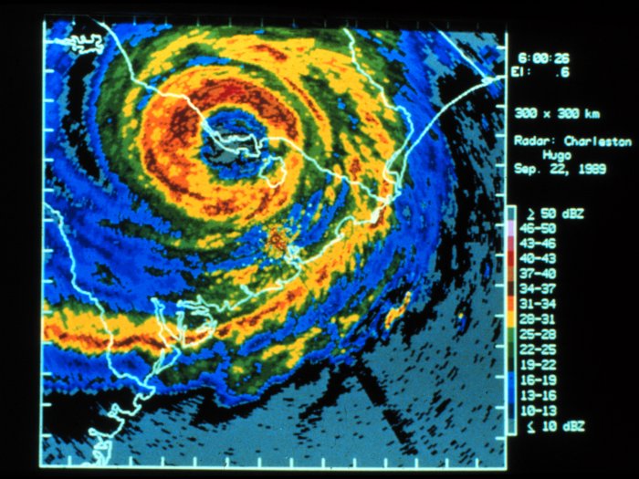
Hugo (1989, 140 mph at landfall in South Carolina) are examples of Category Four hurricanes at
landfall.
- Category Five Hurricane:
- Sustained winds greater than 155 mph (135 kt or 249 km/hr). Catastrophic damage is
expected. Complete roof failure on many residences and industrial buildings will occur. Some complete
building failures with small buildings blown over or away are likely. All signs blown down. Complete
destruction of mobile homes (built in any year). Severe and extensive window and door damage will occur. Nearly
all windows in high rise buildings will be dislodged and become airborne. Severe injury or death is likely for
persons struck by wind-blown debris. Nearly all trees will be snapped or uprooted and power poles downed.
Fallen trees and power poles will isolate residential areas. Power outages will last for weeks to possibly
months. Hurricane Camille (1969, 190 mph at landfall in Mississippi) and Hurricane
Andrew (1992, 165 mph at landfall in Southeast Florida) are examples of Category Five hurricanes at
landfall.
(The above information was obtained from the National Hurricane
Center)
Our website is dedicated to promoting interest in and better understanding of weather. WeatherWing has been the #1
Weather Observer Certification Training source for Oil and Aviation Interests in the Gulf of Mexico since
1998.
Source: http://WeatherWing.com
Copyright 2007 all rights reserved
↑ Back to Top
| 


 Twitter
 Technorati
 Stumbleupon
 Google Bookmarks
 Facebook
 Digg
Digg Blogmarks
 Delicious
 BlinkList
 Yahoo My Web