| |
|
|
|
| CUMULONIMBUS
MAMMATUS |
| Back | Print
|
Bookmark |
|
| |
|
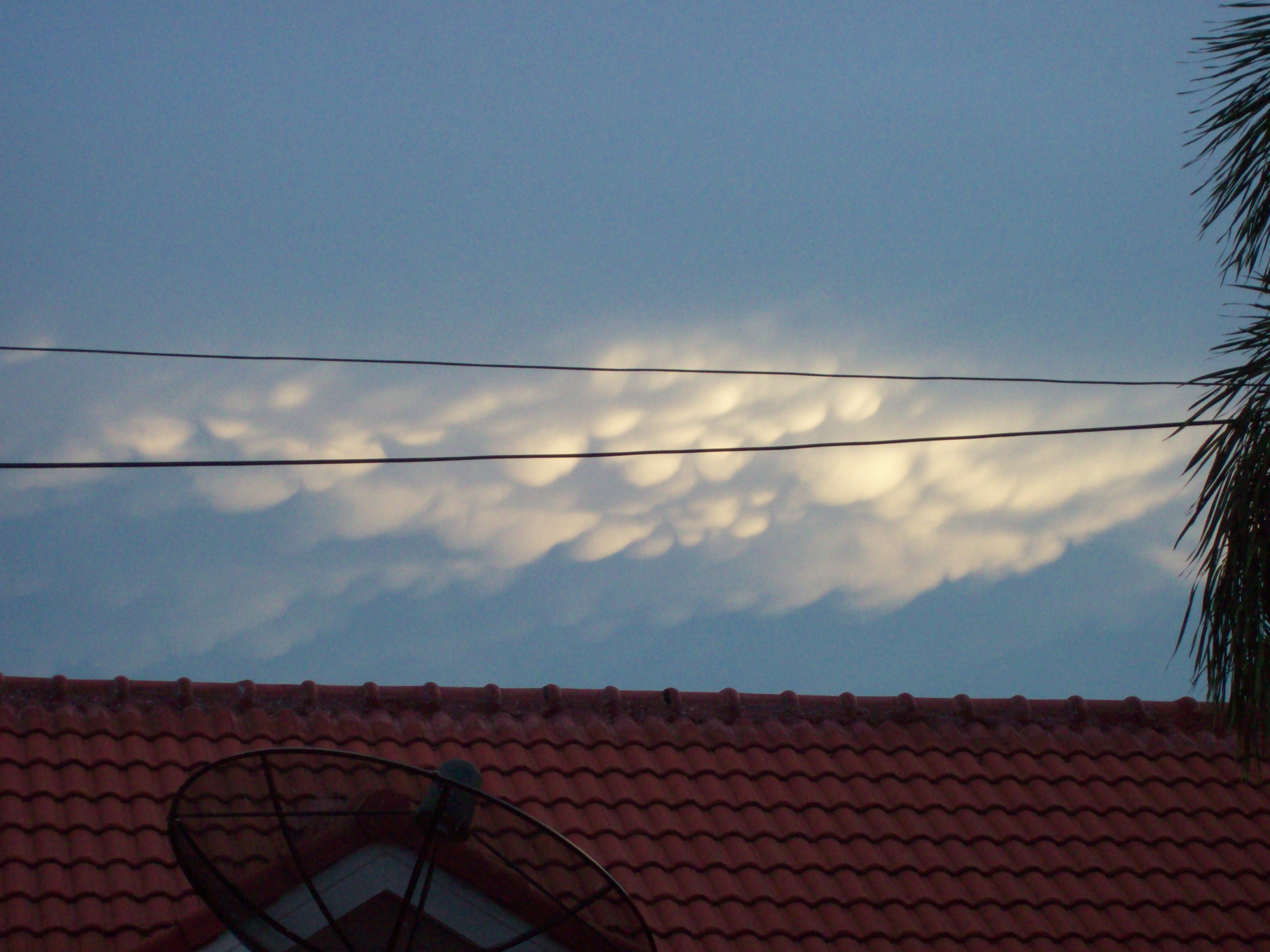
Cumulonimbus mammatus clouds are unique and beautiful cloud formations that grab a viewer’s
attention. If you have seen them, you will remember their unusual pouch-like appearance. Hanging
from the bottom of clouds, there are udder shaped protuberances that inspire the name mammatus,
from the Latin “mamma” breast.

Cumulonimbus mammatus do not cause severe weather but are often associated with particularly
strong, possibly even tornadic storms. Highly turbulent air occurring at the bottom of the clouds
forms the odd shaped pouches, which can be opaque or transparent in appearance. They will also vary
in size. Mammatus clouds can be composed of liquid, ice, or a combination of both.
The intense wind shear within the cumulonimbus cloud that produces the mammatus causes this to be a
cloud that must be specially remarked in aviation weather reports so that pilots can avoid
them.

Although these clouds can be formed all around the United States, they most commonly form in the
middle and eastern states during the warm months of the year. The photographs above were
taken in the summer of 2005, in Lake Charles, Louisiana.
For more information on CUMULONIMBUS, the parent cloud, click
here.

|
|
Photograph by Dominic Clinton
Mr. Clinton
wrote, "These Mammatus appeared briefly today for 5 minutes at about
6pm (sunset) here in Prachinburi, Eastern Thailand. The day has been fairly sunny
with scattered discrete cloud, no haze, light wind, temp about 87-90f. About 45
minutes after the mammatus appeared, a very strong blustery wind started up out of
nowhere, rather like the wind that precedes a big thunderstorm (common here now
early evening, as the rainy season has just begun). The windiness lasted 15
minutes, and then faded away over the course of another 10 minutes. It was a little
odd to have the wind but then no rain - not the usual pattern
here.(Our thunderstorms usually have
"torn" and ragged wisps of small cloud moving in variable directions below the
actual storm cloud - this is almost a guaranteed predictor of heavy precipitation
and lightning.)"
WeatherWing: Mammatus usually do not appear to
come out of the blue without the presence
of the anvil from which they most likely emanated. It had to have been
there, somewhere at some point even though it
may not have been visible to you, since the
pouches form from heavy, dropping, icy water molecules and a CB would
have reached such cold heights.
Mammatus can either precede or trail a system, so the
strong winds you felt may have been related.
|
|
Our website is dedicated to promoting interest in and better understanding of weather. WeatherWing has been the #1
Weather Observer Certification Training source for Oil and Aviation Interests in the Gulf of Mexico since
1998.
Source: http://WeatherWing.com
Copyright 2007 all rights reserved
↑ Back to Top
| Contact Site Map
|
|

"I'd worked as an observer for years, but needed to
re-certify. I learned more in this course than I ever imagined
I could and I passed the exam with flying colors. I am also definately a better observer" TS,
Louisiana
I knew nothing about weather at all. My new
job depended on passing the weather observer certification test. Thanks to the patience and personal
attention you gave us all, the entire class passed. JB, Texas
"When my company sent
me to this class I thought I didn't need the training. I was wrong.
Thanks" RB, Texas
You are the "Gold
Standard" of teaching. Absolutely the best teacher I have ever had. DG,
Louisiana
|


 Twitter
 Technorati
 Stumbleupon
 Google Bookmarks
 Facebook
 Digg
Digg Blogmarks
 Delicious
 BlinkList
 Yahoo My Web